

A look at the Korean psyche through maps : Exhibit honors Joseon cartographers for their accomplishments
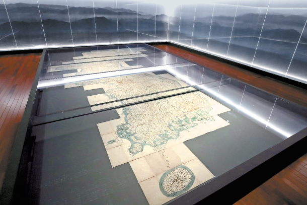
A large Daedongnyeojido, or “Territorial map of the Great East Korea,” which was created by Kim Jeong-ho in 1861, is the largest existing map of Korea, measuring 6.7 meters (22 feet) by 3.8 meters. [YONHAP]
Titled “500 Years of the Joseon Dynasty Maps,” the exhibit displays some 260 maps from the Joseon Dynasty (1392-1910). The vast collection reveals that the people of Joseon had a bit of a cartographic obsession.
“Whenever I saw the maps of Joseon, I was amused by how advanced they are as well as their aesthetic beauty,” said Bae Ki-dong, director general of the museum. “Visitors will definitely be able to feel the emotions of our ancestors in the maps they created.”
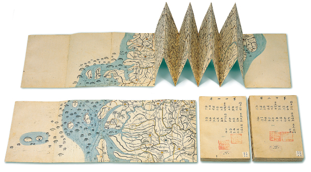
Visitors can take home a pocket map of Daedongnyeojido. [NATIONAL MUSEUM OF KOREA, YIM SEUNG-HYE]
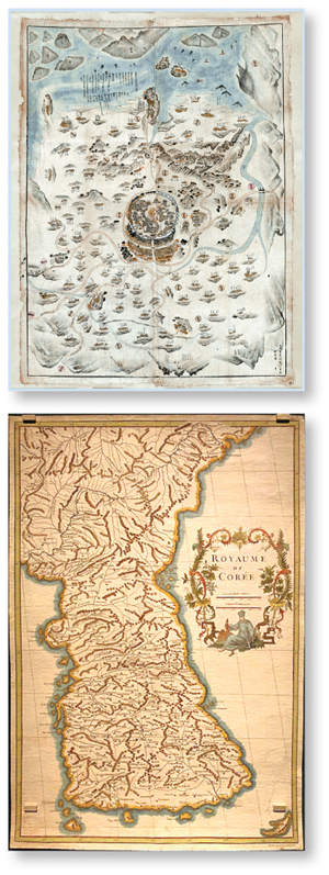
Top: Map of Mujang County in Jeolla (19th Century) Above: Carte du Royaume de Coree (1737) by French geographer Jean Baptiste Bourguignon [NATIONAL MUSEUM OF KOREA, YIM SEUNG-HYE]
According to Baek, Koreans have been creating maps for over 1,500 years, ever since the Three Kingdoms Period (57 BC-668 AD). Maps created during the 500 years of the Joseon Dynasty in particular are praised as significant accomplishments in the history of East Asian cartology, cartography and historical geography, Baek added.
It’s the first time that the National Museum of Korea is using two halls for a special exhibition, not to mention the first time for any museum to so comprehensively display such a wide range of Joseon maps. There’s also one National Treasure on display, the Map of the Korean Territory, or Joseon bangyeok jido, (No. 248), created around 1557.
“I first thought there were too many on display,” said Bae, “but I couldn’t agree more with the curator that they are all too significant to be taken out after going around the exhibition.”
The exhibit is divided into four parts under different themes of Space, Time, Humans and Chronicle.
The first section is where visitors can witness how Koreans in the Joseon Dynasty perceived the world through numerous maps portraying the world.
“One of humanity’s most primary desires would be to understand their own surroundings, and determine where they stand,” said Baek. “Joseon people also tried to understand that by creating maps to reflect the way they viewed the world.”
That view, according to Baek, basically pictured East Asia as the world’s center, and the Joseon people apparently wanted to define themselves as the successor of the “essence of East Asian civilization, as we can see from Joseon maps of the time, which visually embody such intents,” she added. Many of the world maps displayed in this section also mirror well the history of the Joseon people’s contact with Western civilization and their efforts to embrace it. This section also has numerous maps of the Korean peninsula, created by famous geographers and cartographers including Jeong Sang-gi (1678-1752) and Shin Gyeong-jun (1712-81).
The Time section displays maps that feature not just geographical aspects but also records of history of the regions in text as well. According to Baek, creating a map that includes information is a proud tradition of East Asian cartography.
As can be seen in maps such as “Comprehensive and synoptic map of the ancient and modern world,” or “Comprehensive and synoptic map of the ancient and modern Joseon,” created by Kim Su-hong (1601-81), who was a 17th century governmental official and a Confucian scholar, they not only contain information of the present but knowledge of the past as well.
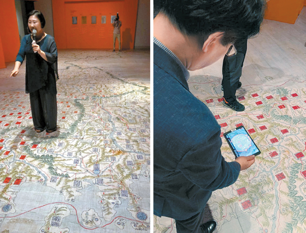
Curator Baek Seung-mi, top, explains the augmented reality section, where visitors can use their smartphones, above, to navigate a print of a Donggukdaejido (Treasure No. 1538). [YIM SEUNG-HYE]
The highlight is in the third section where visitors can view the large Daedongnyeojido, or “Territorial map of the Great East Korea,” which was created by Kim Jeong-ho in 1861. This version is the largest existing map of Korea, measuring 6.7 meters by 3.8 meters. Since this map cannot be hung up, it is spread on the floor inside a glass case.
Other interesting maps can also be seen at the final section, which include maps of Korea created by foreign mapmakers including “Carte du Royaume de Coree,” which was created in 1737 by a French geographer Jean Baptiste Bourguignon d’Anville, and “The Empire of Japan with the Kingdom of Corea” by Robert Sayer in 1790.
BY YIM SEUNG-HYE [sharon@joongang.co.kr]
The exhibition runs until Oct. 28. Tickets cost 6,000 won ($5.41) for adults. Go to Ichon Station, line No. 4, exit 2. Docent tours are available three times a day at 10:30 a.m.; 11:30 a.m. and at 3 p.m. during weekdays and once a day at 10:30 a.m. on weekends. Visit www.museum.go.kr for more information.


with the Korea JoongAng Daily
To write comments, please log in to one of the accounts.
Standards Board Policy (0/250자)