

Hidden trails that highlight Korean beauty
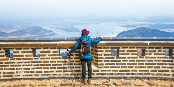
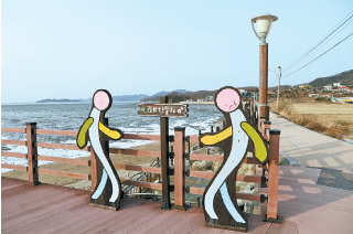
This beautiful view of Jo and Yeomha River from the top of the Mount Munsu Fortress can be found on the outskirts of the Pyeonghwanuri Trail in Gimpo. [KOREA TOURISM ORGANIZATION]
Pyeonghwanuri Trail (Course 2)
This course follows the jogangcheolchaek trail along Mount Munsu, the tallest mountain in Gimpo, Gyeonggi, and over to Jogangri village. This village was once where ships would anchor their boats to get to Hanseong (Seoul’s former name) after sailing the West Sea.
Even if it’s a little off the beaten path, you must try and visit the Mount Munsu Fortress. Here, you can enjoy a panoramic view of Jo and Yeomha River. Located close to North Korea, some sections of this course overlook the heavily guarded border, which will remind you of the harsh realities of the divided peninsula.
Course: South Gate - Munsusanseong Fortress - Hongyemun Gate - Ssangyong-daero - Jogang Reservoir - Entrance of Aegibong Peak (5 miles, 3 hours 20 minutes. Level: Moderate)
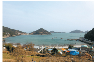
The name of Mijo Port in Namhae, South Gyeongsang, means “The village protected by Maitreya Buddha.” In the spring, you can see the villagers bringing in the anchovies they caught at sea in this beautiful port. The Barae-gil Course 4, which passes by the Mijo Port, is also known as Seomnorae-gil. Barae-gil’s name originates from “Barae ganda,” which was a phrase used by the village women when they left home to gout and catch seafood. This course is perfect in March because the path is not steep and you can catch the budding cherry trees.
Course: Songjeong Solbaram Beach - top of the Mangsan Mountain - Mijo Port - Seolli Beach - Songjeong Solbaram Beach (6 miles, 3 hours 30 minutes. Level: Strenuous)
The Jinhae Dream Road in Changwon, South Gyeongsang used to be a forest trail, but then it turned into the Anmin Road, which is now used for hiking. It is made up of four sections, one of them being the Cheonjabong Haeoreum-gil (Course 2) which is a 10 kilometer (6.2 mile) trail that connects the Anmin rest area to the meeting plaza of Wigallim-gil. The road is surrounded by various kinds of trees, ranging from peach and bamboo to cherry trees. With the escape routes placed here and there, you can stop the hike at any moment along the trek. Throughout the trail, you can see the beautiful scenery of Jinhae and the coastal waters. Starting from Mount Ung all the way to Cheonjabong Peak and Mount Jangbok, the glorious mountain ranges spread out like a folding screen.
Course: Anmin Road (Anmin rest area) - Pyeonbaek rest area - Dream Park Gallim-gil - Cheonjaam - Gallim-gil above the meeting plaza (6.2 miles, 4 hours 10 minutes. Level: Moderate)
This trail follows the apple orchards filled with famous Pyeonggwang Apples at the foot of Mount Palgong. The trail takes about three hours to hike in total. You start from the Hyoja tree Gangsunhang at the entrance of Pyeonggwang-dong, and hike through the small reservoir of Pyeonggwangji finally arriving at the Moyeongjae, which is a house where the stone monument of General Shin Sung-gyeom stands. The time to visit this trail is in the spring (April-May) when you can see the apple blossoms, and in the fall when the apples are ready to be picked. As you follow the apple orchards along the valleys, you will find Cheombaekdang, which is a house built for the spirit of hyoja (devoted son) Woo Hyo-jung and seonbi (scholar) Woo Myeong-sik.
Course: Pyeonggwang-dong entrance - Pyeonggwang Elementary School - Pyeonggwangji - Moyeongjae - Jaebau farm - Cheombaekdang - Pyeonggwang station (Round-trip 4.6 miles, 2 hours 30 minutes. Level: Easy)
Ganghwa Naeul-gil (Course 11) in Incheon is a place where you can fully experience the beauty of Seongmodo Island. Starting from Seokpori dock, you can walk by dark-colored ditch and see the vast tidal mudflats unfold in front of you. After passing by Bomun dock and a fishing port while walking along the Jebang-gil road, you will pass through a quiet and peaceful forest. At the far end of the forest, there is Seongmodo Island’s one and only beach called Minmeoru Beach. Keep walking along the Jebang-gil with the sea on your left and Mount Nakga on the right, and you will arrive at Bomun Temple where this course ends. Don’t forget to stop by Bomun Temple after your hike to take in the beautiful scenery of the West Sea.
Course: Seongmodo dock - Maeeum-ri dock - Fishing port - Minmeoru Beach -Eoryujeonghang - Bomunsa (10 miles, 5 hours. Level: Easy)
Gangjin Baseurak-gil (Course 1)

In Gangjin of South Jeolla, there is a mountain called Mount Mandeok, which has an altitude of slightly over 400 meters. The mountain, though it seems like any other peak in Korea, is special because it is home to BaekRyeon Temple, camellia groves and the House of Dasan - the Yubaecheo (house of exile) of Jeong Yak-yong, who was often referred to as “Dasan” and is known as a great thinker of the late Joseon period (1392-1910). It is a sacred mountain where “Dasan” and “Haejangseonsa” of BaekRyeon Temple built a friendship and ancient Koreans left trails of their lives over many years. Mount Mandeok is connected to another mountain called Mount Seokmun and there is a viaduct that links the two mountains.
Course: BaekRyeon Temple - Dasanchodang - Majeom village - Yongmun Temple - Seokmun park - Soseokmun - Doam Middle School- Doammyeon office (5 miles, 2 hours 30 minutes. Level: Moderate)
Jeongbangsa-gil in Jechon

Jeongbangsa-gil in Jechon, North Chungcheong is a road full of breathtaking scenary from beginning to the end. It is a 1.6-kilometer (1 mile) course starting from Neungganggyo and ending at Jeongbang Temple. Below Neungganggyo, where the road begins, lies Neunggang Valley. Rocks of many different sizes and trees taking root in the rocks display quite an attractive landscape that is hard to spot elsewhere. The most appealing part of this road is the landscape viewed from Jeongbang Temple, which is the end of the road.
Course: Neungganggyo - Jeongbang Temple (1 mile, 1 hour. Level: Moderate)
Chungju Punggyeong-gil Jongdaengi-gil

Jongdaengi-gil is a road that connects a mountain and a lake located in Chungju in North Chungcheong.
Mount Gyemyeongsan guards the city of Chungju, and it is known for its beauty with its impressively-shaped Ambong Peaks. This mountain has the best view of the downtown area and Lake Chungju.
The park at Mount Gyemyeong sticks out toward Lake Chungju like a fist. This little mountaintop is known as Mount Simhang. Jongdaengi-gil is a forest road that circles Mount Simhang and as you trek along the trail, you can see the beautiful Lake Chungju. The road follows the slope of the mountain and there are many observatories nearby where you can enjoy a variety of marvelous views.
Course: Majeumakjae parking lot - Pathway - Eco Pond - Observatory 1 - Octagonal Pavilion - Observatory 2 - Suspension Bridge - Hexagon Pavilion - Mount Gyemyeong Natural Recreation Forest - Majeumakjae parking lot (4.6 miles, 3 hours. Level: Easy)
BY CHOI SEUNG-PYO [sung.jieun@joongang.co.kr]


with the Korea JoongAng Daily
To write comments, please log in to one of the accounts.
Standards Board Policy (0/250자)