

Walk into nature, and a perilous past

The campsite along the dirt trail through Mount Chungnyeong, originally blazed to move trees, can accommodate a total of 10 tents. [JoongAng Ilbo]
Swiss-born novelist and entrepreneur Alain de Botton noted in “The Art of Travel,” his insightful essay on the revitalizing power of nature, “the consoling idea that in vacant or pensive moods, in traffic in the city’s turbulent world, we may also draw on images of our travels through nature, images of a group of trees or a spread of daffodils on the shores of a lake, and with their help, blunt a little the forces of enmity and low desires.” In the places depicted on the following pages, walking is more than a way to burn fat. It’s a sacred chance to escape the suffocating rat race and exercise the mind, building up memories to offer comfort in difficult times.
Before the airplane, the car, the wheel, to travel was to walk. No one is ever alone on a walking tour: The whispering trees, the grass and the birds are ever-present companions.]
Recently the Olle paths in Jeju and the trail up Mount Jiri have attracted special attention in Korea. But one doesn’t have to run with the crowd - there are plenty of other, perfectly accessible places to venture on foot. Here are just a few.
Ganghwa Island
A walk on the island of Ganghwa is like stepping into a coffee table hardcover.
Breathtaking mountains, sea and sky hide a startling number of important historical and cultural sites. The best part: This relaxing oasis is just one hour away from the smog and stress of Seoul.
Ganghwa Island has been called a “museum without a roof” because of its many historical sites. The oldest is Chamseongdan, a stone altar on Mount Mani where Korea’s mythical founder Dangun supposedly performed rites to appease the heavens. A cluster of prehistoric dolmens on Ganghwa Island has been designated a Unesco World Heritage site. The island was also a battleground during the Mongolian invasion in the Goryeo Dynasty (918-1392).
In modern times, Ganghwa Island again became the target of foreign invaders, and battles took place there with the French in 1866 and the United States in 1871. This military history is reflected in the 53 stone dondae, military posts built along a beachside path to ward off invasion from the sea. The island was also a temporary home for many refugees who fled from the North during the Korean War.
The most common way to enjoy the island involves a walk along the path between the dondae. The official route is divided into four sections. The first is the History-Culture Path, which is about 13 kilometers (eight miles) and takes some four hours to walk. The second is the 15-kilometer Patriotic Dondae Path, taking five hours. The Pathway to the Historical Tombs, an 18-kilometer section, takes another seven hours, and the last is the Sunset Village Path, a relatively easy 4.25 kilometers.
The History-Culture section includes a visit to Gwang-hwasanseong, which served as the temporary capital of the Goryeo Dynasty; the ruins of the Goryeo palace; Yongheun Palace; and the Anglican Church of Ganghwa, with its traditional Korean-style chapel. After that, the path to Yeonmijeong Pavilion overlooks the picturesque fields of Daesan village, providing a taste of rural Korea.
The second section highlights the strategic military location of the island, where the Han and Imjin rivers meet. Barbed wire runs along the waterfront, a reminder of the division of Korea. There are also remains of historical military camps and bases as well as the 53 dondae.

The sunset from Ganghwa Island on Korea’s west coast is one of its most striking sights, bathing old battlefields in a blood-red glow.
Unlike the Olle trails in Jeju, the Ganghwa Island Pathway is not universally famous. Yet it is a quaint and idyllic walk to be thoroughly enjoyed. Since Ganghwa Island is so easily accessible from Seoul by public transportation, one can leave with pockets as light as one’s heart.
More information can be found at www.ganghwa.incheon.kr.
Getting There
A bus runs frequently from Sinchon in Seoul to the Ganghwa Bus Terminal. The trip takes approximately 1 hour and 50 minutes and costs 4,200 won.
Places to Eat
Seohae Bokhwejib (032-933-7514)
Located near the Changhuri Inlet, this restaurant is easy to find and boasts a great sunset view. It serves blowfish, wild river puffers and seasonal fresh fish. Lodging is also available.
Pureun Eondeok (032-934-2151)
Ten minutes from downtown Ganghwa-eup, next to the Songhae Post Office, this place is famous for its soy sauce-seasoned crab and rice simmered in earthenware bowls. Also recommended is the fish and rice set, a real value for its price.
Mount Chungnyeong
Mount Chungnyeong is a magnificent mountain located between Jangseong County in South Jeolla and Gochang County in North Jeolla. It’s the largest forested area in the country, with 62 hectares of cedar, 143 hectares of cypress and 55 hectares of larch trees - all planted with dedicated care over 32 years, from 1956 to 1987, by the late Lim Jong-guk. The main part of the forest consists of cedar and cypress, which typically live 30 to 50 years. The average height of the trees is 18 meters, at a density of some 700 to 2,500 trees per hectare.
The cypress woods at Mount Chungnyeong are now known for their supposed health benefits. The tall cedar and cypress trees cover the land with a blanket of cool air even during the summer. Proponents of the practice of “forest bathing” believe the phytoncides emitted by the coniferous forest calm the mind and body and strengthen lung function, helping alleviate bronchial asthma. Some patients suffering from skin diseases or even terminal cancer visit the area hoping to gain these benefits.
Because it is a private forest, for a long time Mount Chungnyeong did not appear on most maps. But in time its spectacular greenery made it a popular location for movies and TV dramas. Im Kwon-taek’s classic “The Taebaek Mountains” (1994) and “The Harmonium in My Memory” (1999) were both shot in Geumgok Village at the foot of the mountain.
The village was also the first to win the grand prize for “Most Beautiful Forest” in a campaign co-hosted by the Korea Forest Service in 2000.
Past the village, a mountain path leads into thick foliage, and up a moderate slope. This trail was originally blazed to transport trees, but today it seems all-natural, running six kilometers (3.7 miles) between the villages of Munamri and Moam. Though the dirt route can be traveled by car, it is much better on foot.
The campsite and spring alongside it can accommodate up to 10 tents.
Walking through the woods and breathing the fresh air does wonders for one’s heart.
Sightseeing
Hong Gil-dong’s Birthplace
Hong Gil-dong is both a character in a novel by Heo Gyun and a real person. Known as “the Robin Hood of Korea,” Hong was born into a noble household in the mid-15th century in the Joseon Dynasty (1392-1910), but was shunned because he was the offspring of a concubine.
He gathered a group of rebels fighting for social justice, who called themselves Hwalbindang. Unfortunately, he was pursued and finally arrested by the authorities and exiled to Namhae. Hong later escaped, leading the group to Okinawa.
A joint research project conducted by Korean and Japanese scholars has traced the course of the real Hong’s life, and Jangsung County established a Hong Gil-dong museum in 2004.
Places to Eat
Sangoljjagi (061-393-0955)
Pheasant may be delicious, but it’s a rarity and even trickier to cook, making this restaurant near the entrance to the Hong Gil-dong Village a special treat. The restaurant’s specialty is sukiyaki with pheasant meat, plus optional noodles or rice cakes. The pheasants are raised in a plot right next to the restaurant, so diners can see the birds for themselves.
Haneuljae and Mungyeongsaejae
Mireuk Temple on Mount Worak in Jecheon, North Chungcheong, boasts an impressive three-story stone pagoda. Just to its left is a modest trail lined with pine and oak trees, fanned by a cool breeze under a clear sky. This is Haneuljae. Though it is only a half-kilometer (1,600 feet) long, it’s one of the oldest paths connecting North Chungcheong in the west and North Gyeongsang in the east. The name means “Sky Hill” because it seems to touch the sky. The bumpy dirt trail turns to asphalt at the crest of a ridge, offering a view of the 1,115-meter high Mount Daemi to the west.
Haneuljae is estimated to be around 1,300 years old. First established during the Silla period, it was a major thoroughfare on the peninsula through the Japanese invasion of 1592 to 1598. It lost its central role when new roads were built to cut through the hills of Joryeong and Ihwaryeong.
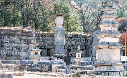
Stone lamps and pagodas and a standing Buddha watch over the site of Jungwon Mireuksaji Temple, built in the 11th century during the reign of the Goreyo Dynasty.
Sightseeing
Jungwon Mireuksaji
This temple was built in the 11th century during the early days of the Goryeo Dynasty, but later burned down during the Mongolian invasion. Still, the site has a stone statue of a standing Buddha, a five-story stone pagoda, a stone lamp, another three-story stone pagoda and two unique pillars.
Old Mungyeongsaejae Path
This was part of Yeongnam Road, the biggest road connecting the southeastern part of the peninsula with Hanyang, or Seoul, which was the Joseon-era capital. It was an important route for its economic functions, its military significance and as a crossroads of culture. The old path is about 6.5 kilometers long, stretching from the first gateway of Mungyeongsaejae to the third. Today it has been preserved as a yellow earth road and plays a significant role in local tourism. It is the perfect place to visit after a walk down Haneuljae. The path has also been used as a setting for historical TV dramas and attracts visitors from around the country with its deep forests, beautiful nature and historical sites.
Places to Eat
Jungangtap Orijip (043-857-5292)
Duck meat is usually greasy, and is generally roasted, but there is another delicious way to prepare it - in a stew with medicinal herbs.
It’s also entertaining to watch the experienced wait staff separate the meat from the bones with deft skill. White kimchi and cucumber kimchi are also treats suitable for foreign guests who are not used to Korea’s spicy dishes.
By Lim Ji-soo Contributing writer [estyle@joongang.co.kr]


with the Korea JoongAng Daily
To write comments, please log in to one of the accounts.
Standards Board Policy (0/250자)