

Unstable atmosphere blamed for torrents
According to the weather agency, the heavy rain that started Tuesday set records in some areas of the country.
Seoul, Gyeonggi, western Gangwon and the southern coastal area of South Gyeongsang saw rainfall of more than 60 millimeters (2.3 inches) per hour, the weather agency said.
As of 3 p.m. yesterday, Seoul has endured 430 millimeters of rain since Tuesday. The amount is nearly one-third of the capital city’s average yearly precipitation of 1,450.5 millimeters.
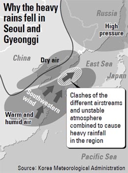
“The warm, wet air that came down with a strong southwestern wind along the edge of the Northern Pacific High Pressure Zone clashed against the dry air located in the lower atmosphere, severely destabilizing the atmosphere,” the weather agency said. “Furthermore, the blocking high-pressure system located near Sakhalin, northeast of Korea, has slowed down the airflow, triggering torrential downpours.”
When warm air is located underneath cold air, a convective flow is created, prompting torrential downpours, the agency said. “When you boil water, you will see a pop in some places,” said Chung Kwan-young of the meteorological administration. “Just like that, you will see torrential downpours where the convective flow is created, prompting heavier rainfall than other areas.”
The weather agency said up to 250 millimeters more rain will fall in the central region until Friday. The downpour was expected to be the strongest between last night until this morning, it warned, adding that strong wind gusts, thunder and lightning will accompany rain of more than 60 millimeters per hour.
The latest rainfall apparently was heavier than the regular seasonal summer rain, which took place from June 22 till July 17 this year. During the period, the heaviest daily rainfall in Seoul was 177 millimeters on June 29.
Seoul received 440.5 millimeters of rain from Tuesday when the rain started to Wednesday at 6 p.m.
The amount of rain falling in Seoul is nearly at record levels. The most precipitation recorded in the city in a single day was 354.7 millimeters on Aug. 2, 1920.
The weather agency said that for the duration of the storm - Tuesday until Friday - more than 600 millimeters of rain are expected to fall.
By Ser Myo-ja [myoja@joongang.co.kr]
한글 관련 기사 [머니투데이]
`한국형 스콜`, 계절 구분없이 `물폭탄`
지난 26일부터 3일째 서울·경기를 비롯한 중부지방에 물폭탄이 내리고 있다. 27일에는 기상관측 사상 일간 강우량이 3번째로 많은 301mm의 비가 쏟아지며 서울을 초토화시켰다.
공교롭게도 이번 집중호우는 장마가 끝난 직후 시작됐다. 과거에는 장마가 끝나고 나면 태풍이 올 때를 제외하고는 비가 많이 오지 않았다. 대신 무더위가 이어지면서 여름은 `장마 + 무더위`로 구분됐다.
하지만 최근 들어 그 구분이 모호해지고 있다. 한국의 기상도가 바뀌고 있는 것이다. 최근 몇년을 보면 장마가 끝난 여름, 심지어 가을에도 국지성 집중 호우가 자주 내렸다. 장마가 시작되기 전인 늦봄에도 집중호우가 내리기도 했다.
이에 학계 일부에서는 "이제 여름을 `장마`와 `무더위`로 나누는 것은 의미가 없다"며 `우기`로 표기하고 늦봄부터 초가을까지 `비`를 관리해야 한다는 주장도 나오고 있다.
◇서울 강타한 `호우`, 아열대성 `스콜`인가?
이번에 중부지방에 큰 피해를 입힌 집중 호우는 현상으로만 보면 열대나 아열대기후에서 내리는 `스콜`과 유사하다. 때문에 `한국형 스콜`이라는 소리도 나온다. 열대성 스콜은 햇볕이 내리쬐다가도 갑작스럽게 국지성 호우가 쏟아지고, 다시 언제 그랬냐는 듯 비가 그치면서 태양이 등장한다.
이번 국내 호우의 경우 하늘에서 태양을 보기 어렵고, 강우의 강도 역시 열대성 스콜보다 약해 분명히 차이가 있다. 하지만 짧은 시간에 좁은 지역에 강한 비를 퍼붓다가 그치고, 얼마 후 다시 강한 비를 퍼붓는 형태는 스콜과 흡사하다.
하지만 일부에서 주장하는 것처럼 한국 기후가 아열대성으로 바뀌면서 이처럼 스콜과 유사한 집중호우가 쏟아진다고 보기에는 무리가 있다. 열대성 스콜과 이번 집중호우의 발생원인에 차이가 있기 때문이다.
열대성 스콜은 지표면이 강한 햇볕으로 달궈지면서 대기중으로 상승한 따뜻한 공기가 거대한 비구름대를 만들어 비를 뿌리는 것이다. 하지만 이번 집중호우는 장마전선을 형성하고 있던 북태평양고기압과 오오츠크해고기압이 예년처럼 움직이지 않고, 북서쪽의 소규모 상층 기압골이 자주 한반도로 넘어오는 등 대기가 불안정하면서 나타난 현상이다.
기상청 관계자는 "한반도 상공에 성질이 다른 3개의 공기 중 2개 이상이 부딪히면서 해당 지역의 대가가 불안정해져서 소나기가 쏟아지고 있다"며 "장마처럼 넓은 지역에 비가 내리는 것이 아니라 국지적으로 집중해서 내리는 이유"라고 설명했다.
◇대기 왜 불안한가? 29일까지 비 예보
일반적으로 장마가 끝나면 장마전선을 형성했던 두 고기압 중 고온의 북태평양고기압이 저온의 오호츠크해고기압을 북쪽으로 밀어낸다. 때문에 한반도는 북태평양고기압의 세력에 들고 무더위가 찾아오는 것이다.
하지만 올해는 장마가 끝난 후 북태평양고기압이 예년과 달리 한반도 전역으로 커지지 못했다. 이는 오호츠크해고기압도 완전히 북쪽으로 물러나지 못했다는 이야기다. 최근 일본으로 비켜간 태풍 `망온`으로 인해 기압들이 예년처럼 움직이지 못했다는 분석도 있지만 단지 그 하나만의 이유로 보기는 힘들다는 게 중론이다.
어쨌든 현재 한반도 상공엔 북태평양고기압과 일부 남아 있는 오호츠크해고기압, 그리고 북서쪽에서 넘어오는 건조하고 차가운 공기 등 3개의 다른 대기가 충돌하면서 많은 비를 뿌리고 있는 것이다.
기상청은 "우리나라 북동쪽 사할린 부근에 위치한 저지고기압으로 인해 기압계의 흐름이 정체되고, 강한 남서풍을 타고 유입된 따뜻하고 습한 공기가 건조한 공기에 부딪치면서 대기불안정이 강화돼 집중호우가 발생했다"며 "중부지방에서는 29일 오전까지 비가 이어지면서 최대 250mm 이상의 많은 비가 더 내릴 것"이라고 예보했다.


with the Korea JoongAng Daily
To write comments, please log in to one of the accounts.
Standards Board Policy (0/250자)