

3-D indoor maps on the way
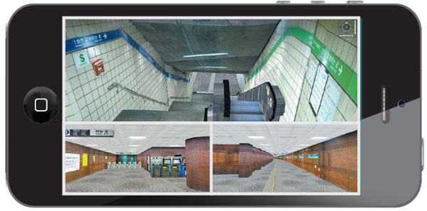
Three-dimensional images of City Hall subway station, line No. 1 and No. 2, are shown on a mobile device. Provided by the ministry
A mobile application that will provides three-dimensional floor plans for large, complicated indoor spaces is expected to be available from the ministry within the first half of the year. It will be the first 3-D indoor map service in the world.
The app will start with the a map of City Hall subway station, lines No. 1 and No. 2, and follow with 3-D maps for busy Gangnam Station on line No. 2 and Incheon International Airport available by the end of the year.
Like a car navigation system, the application will also have a voice service to make it easier to find particular shops located under Gangnam Station.
There also will be an option that provides directions for handicapped accessible routes.
“Although Korea has fallen behind in developing its own outdoor navigation service, it has focused on underdeveloped 3-D indoor location services, especially for the people who get lost in places where GPS signals are not available,” says Sa Jae-gwang, director of the Land Ministry’s location information planning team. “We have been actively researching commercialization of the indoor location service since 2007 to be a leader in a new market.”
The ministry says the technology uses Wi-Fi signals to track the location of mobile devices running the app and use the 3-D map service to produce images.
The ministry expects the global market for location information technology will expand to 150 trillion won in 2015, according to the American research company Daratech. Korea’s goal is to secure at least a 10 percent share.
By Lee Sun-min [summerlee@joongang.co.kr]


with the Korea JoongAng Daily
To write comments, please log in to one of the accounts.
Standards Board Policy (0/250자)