

Old maps used to verify East Sea argument
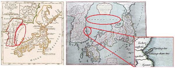
Left: Le Japon, from France in 1749, indicates the East Sea as Mer De Coree. Right: The Empire of Japan, created by the United Kingdom in 1794, calls the sea the Corean Sea and Ulleung Island Fanling-tao, and Dokdo Tchiang-chan-tao. Provided by the National Geogrpahic Information Institute
The National Geographic Information Institute said yesterday it found archaic maps made by Japan and some Western countries that clearly indicate the East Sea as belonging to Korea.
The institute also held an exhibition of about 50 maps as evidence in Suwon, Gyeonggi yesterday.
Korea and Japan are dueling over the proper name of the East Sea. Japan calls it the Sea of Japan.
Western countries called the body of water the “Sea of Coree” in maps made before the 17th century. Those maps were imported by Japan and it used the same moniker on maps in the 19th century, according to the institute.
Le Japon, made in 1749, and Carte De Province De Quantong ou Lyau-tong et du Royaume de Kau-li ou Coree, made in 1750 by France, call the sea “Mer de Coree,” the institute showed.
The Empire of Japan, made in 1794 by the United Kingdom, indicated the area as “Corean Sea.” Ulleung Island and Dokdo were written as Fanling-tao and Tchiang-chan-tao, marking them as Korean territories.
Two Japanese maps made in 1810 and 1865 also indicate the “Sea of Joseon.”
Experts gathered at a forum to discuss measures to make the East Sea the international standard. Seo Jeong-cheol, professor emeritus at Hankuk University of Foreign Studies, led the forum.
Seo said studying archaic maps is very important in finding legitimacy for the name East Sea.
“Archaic maps are the most important historical data, but we should be careful when we study them, because those maps were made in accordance with various power dimensions,” the professor said.
According to him, Japan’s argument that the East Sea should be called Sea of Japan gained ground in the 19th century when Japan was on the rise in terms of national power. In the 17th and 18th centuries, many Western countries indicated the sea as Korea’s.
“It is historically legitimate to say the East Sea is ours, as proven by the maps of Western countries before the Empire of Japan,” said an institute official. “The institute will continue collecting archives and data to make East Sea an international standard.”
Last year, the French publisher of one of the world’s most authoritative world atlases started using both the Korean and Japanese monikers for East Sea.
BY SONG SU-HYUN [ssh@joongang.co.kr]


with the Korea JoongAng Daily
To write comments, please log in to one of the accounts.
Standards Board Policy (0/250자)