

Typhoon Danas to soak Korea this weekend
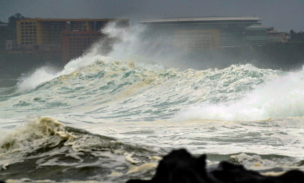
Waves crash on the shore of Seogwipo in southern Jeju Island Friday as the country braced for Typhoon Danas, which was expected to bring heavy rain and strong winds across Korea today. [YONHAP]
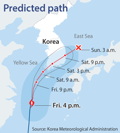
By Friday 4 p.m., the typhoon was in waters 430 kilometers (267 miles) southwest of Jeju Island’s southern city of Seogwipo, heading northeast towards mainland Korea at a speed of 16 kilometers per meter (10 miles per hour), said the Korea Meteorological Administration (KMA).
Typhoon Danas was expected to reach the country’s southern coastline this morning and continue traveling northeastward toward the East Sea. The KMA expected the typhoon to arrive at the eastern coast by Saturday 9 p.m., though rain was likely to fall in many areas for several more hours.
Rain clouds associated with the typhoon were growing heavier Friday afternoon, bringing showers to Jeju Island, South Jeolla, South Gyeongsang, Busan and Ulsan.
The entire country was expected to experience heavy rain and wind this morning. As the typhoon travels northeast, rain was expected to fall off on the west side of the country early Sunday morning. In the following hours, rain was expected to stop in all of Korea, though the east side of Gangwon was expected to see more rain through Sunday due to an east wind.
By Saturday midnight, Jeju Island and southern coast areas were expected to receive 150 to 500 millimeters of rain, while mountainous regions of Jeju were forecasted to receive 700 millimeters or above. Most areas in east Gangwon, South and North Gyeongsang, South and North Jeolla were expected to receive 50 to 150 millimeters, though some areas in South Jeolla as well as North and South Gyeongsang could have 200 millimeters or more, the KMA said. Seoul, Gyeonggi, east Gangwon, North Chungcheong, South Chungcheong, Ulleung Island and the Dokdo islets were likely to get 10 to 70 millimeters of rain.
The KMA spokesperson warned Jeju and some other mountainous regions near the southern coast, such as Mount Jiri, of landslides and flooding from Friday night to Saturday daytime, saying that in the worst hours, those areas could be pounded with 50 millimeters or more rain per hour.
As the typhoon nears mainland Korea, winds will also grow faster. The wind speeds in Jeju, South Jeolla and South Gyeongsang will reach about 54 to 72 kilometers per hour.
BY KIM JEONG-YEON [lee.sungeun@joongang.co.kr]


with the Korea JoongAng Daily
To write comments, please log in to one of the accounts.
Standards Board Policy (0/250자)