

175-year-old Japanese map shows ‘Joseon Sea’
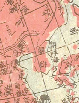
A map believed to have been produced by a Japanese man in the early 19th century labels the sea between the Korean Peninsula and Japan as the Sea of Joseon, not the Sea of Japan or East Sea. [YONHAP]
Joseon is the name of Korea’s final dynasty. Korea is lobbying the international community to stop using the term Sea of Japan, saying it’s a legacy of 20th century colonialism and is not the sea’s traditional name. North and South Korea use the name East Sea.
Kim Moon-kil, an honorary professor at Pusan University of Foreign Studies, disclosed the map to local media. He said he recently acquired it in a bookstore in Japan.
On the map, the sea between Korea and Japan was labeled Sea of Joseon in Chinese characters. The term Sea of Japan was used on the map, also in Chinese characters, but to describe the Pacific Ocean to the east of Japan.
The map included an explanation that it was produced in 1835 as a Japanese translation of a French map.
Kim speculated that the map was made by Japanese mapmaker Sogo Minosaku. He said it is the oldest Japanese map found so far that refers to the East Sea as the Sea of Joseon.
Next month, the International Hydrographic Organization is expected to adjudicate the definitive name for the sea. Last week, Seoul told the organization it would accept the concurrent use of the terms Sea of Japan and East Sea.
Kim said he studied 128 old maps in Korea, China and Japan and 80 of them used the term Sea of Joseon, while 20 others used East Sea. Only 11 of them used Sea of Japan, and all of them were made after the Russo-Japanese War from 1904-1905, he said.
By Moon Gwang-lip [joe@joongang.co.kr]
한글 관련 기사 [연합]
동해 ‘조선해 표기’ 1800년대 日고지도 발굴
김문길 교수 입수…‘일본해는 일본 동쪽 바다’
현재의 동해를 조선해(朝鮮海)로, 태평양 쪽 일본 동쪽 바다를 대일본해(大日本海)로 표기한 1800년대 초반 일본 고지도가 발굴됐다.
일본이 과거 스스로 현재의 동해를 일본해가 아닌 조선해로 표기했음을 의미하는 것이다. 이는 현재 한일 간 동해-일본해 표기 싸움에서 일본 측 주장의 설득력을 떨어뜨리는 근거로 작용할 수 있을 것으로 보인다.
한일문제 전문가인 김문길(부산외국어대 명예교수) 한일문화연구소장은 3일 연합뉴스 기자와 만나 동해를 조선해, 일본 동쪽 바다를 대일본해로 표기한 일본 고지도를 공개했다.
김 소장이 최근 일본 고서점에서 입수한 이 지도에는 `불란서인이 만든 지도를 입수해서 보니 외래어로 돼 있어서 일본 한자로 (표기를) 고친다`는 지도 설명과 함께 제작연도가 1835년으로 적시돼 있다.
특히 지도는 한국과 일본을 포함한 서반구(西半球)와 유럽 중심의 동반구(東半球) 등 두 부분으로 구분돼 있다.
김 소장은 "고지도에 제작자 표시는 없지만 미노사쿠 소고(箕作 省吾)라는 일본인이 틀림없으며, 그동안 공개된 조선해 표기 고지도 가운데 가장 오래된 것으로 보인다"고 밝혔다.
김 소장은 스이도 호우(翠堂彭)와 다카하시 가케야스(高橋 景報)가 각각 1852년과 1875년에 제작한 조선해 표기 고지도 사본을 공개한 적이 있지만, 이들 지도는 미노사쿠의 지도를 보고 그린 것이라고 설명했다.
그는 "스이도와 다카하시가 그린 지도에는 `미노사쿠가 그린 양구도(兩球圖,서반구ㆍ동반구)를 참조해서 그렸다`는 설명이 있다"고 말했다.
그는 다만 소장한 미노사쿠의 지도는 종이 전문가에 의뢰해본 결과 메이지 시대인 1800년대 후반에 다시 찍은 것으로 보인다고 덧붙였다.
그는 `불란서인이 만든 지도를 고쳤다`는 지도 설명에 대해 이탈리아 예수회에 소속돼 프랑스 선교단의 일원으로 중국에서 선교활동을 벌인 마테오리치가 1602년에 그린 지도를 의미하는 것으로 학계에서는 이해하고 있다고 전했다.
미노사쿠가 마테오리치가 그린 지도를 참조했다는 설명이다.
김 소장은 일본은 물론 한국, 중국 등의 고지도 128개를 조사해보니 동해가 조선해로 표기된 지도가 80개, 동해로 표기된 것이 20개, 일본해로 표기된 것이 11개 정도 됐다고 말했다.
그는 그러나 일본해 표기 지도는 모두 1905년 러일전쟁 전후에 제작된 지도라며 일본이 러일전쟁을 계기로 조선해를 일본해로 표기해 독도를 침탈하려는 의도가 담긴 것으로 보인다고 풀이했다.
그는 "일본 고지도에서 동해를 조선해로 표기하고 있고, 일본이 주장하는 일본해는 동해 쪽이 아닌 일본 동쪽 바다를 적시하고 있다"면서 "국제수로기구(IHO) 등을 통한 일본과의 동해 표기 싸움에서 동해가 아닌 조선해로 주장하는 것이 더 설득력이 있다"고 강조했다.


with the Korea JoongAng Daily
To write comments, please log in to one of the accounts.
Standards Board Policy (0/250자)