

The North and South disagree on boundaries after the Korean War
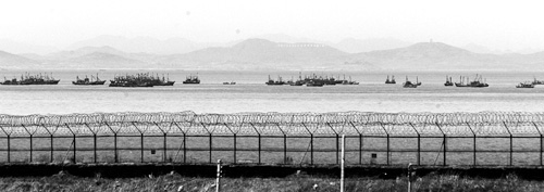
Beyond the military fences on Yeonpyeong Island, boats fish for crab. [JoongAng Ilbo]
In particular, redrawing the maritime border in the Yellow Sea is a constant topic of discussion for Pyongyang.
The Northern Limit Line that now serves as a maritime border between the two Koreas was established by General Mark Wayne Clark, the UN commander, at the end of the Korean War. Nevertheless, the armistice that ended the Korean War does not include the Limit Line because the North and the United Nations did not come to an agreement. Instead, the armistice includes a passage referring to the withdrawal of forces along the coastlines.
It reads: “Within 10 days after this armistice agreement becomes effective, withdraw all military forces, supplies, and equipment from the rear and the coastal islands and waters of the other Korea. If such military forces are not withdrawn within the stated time limit, and there is no mutually agreed and valid reason for the delay, the other side shall have the right to take any action which it deems necessary for the maintenance of security and order.
“The term coastal islands as used above, refers to those islands, which, though occupied by one side at the time when this armistice agreement becomes effective, were controlled by the other side on June 24, 1950; provided, however, that all the islands lying to the north and west of the provincial boundary line between Hwanghae and Gyeonggi Provinces shall be under the military control of the Supreme Commander of the Korean People’s Army and the Commander of the Chinese People’s volunteers, except the island groups of Baengnyeong, Taechong, Sochong, Yeonpyeong and Udo, which shall remain under the military control of the Commander-in-Chief, United Nations Command. All the islands on the west coast of Korea lying south of the above-mentioned boundary line shall remain under the military control of the Commander-in-Chief, United Nations Command.”
After the war, the designation Northern Limit Line was used primarily by U.S. and South Korean forces. The line was established by General Clark to prevent possible clashes, and since the North didn’t have any real naval forces to speak of at the time, it was only a matter of controlling the naval traffic from UN and South Korean forces. When UN forces withdrew, hastily established North Korean naval forces filled the void at the northern part of the line and the maritime border was established automatically without any quarrel.
Things started to change in October and November of 1973, when North vessels intentionally crossed the line more than 40 times. The North said in December military talks that it could not accept the line because it represented a one-sided decision.
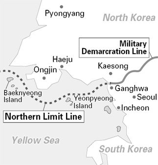
The line runs between the mainland portion of Gyeonggi Province that had been part of Hwanghae before 1945, and the adjacent offshore islands, the largest of which is Baengnyeong. As a result, the mainland portion reverted to North Korean control, while the islands remained a part of South Korea.
At the latest military talks held earlier this month, Pyongyang brought up the issue of the Northern Limit Line again, with the aim of pushing the line south. In the past, the North has also argued that the military talks redrawing the maritime border should take place between Pyongyang and Washington only. The United Nations, which usually refrained from raising the line issue, told the North Koreans in June of 1999 that the line would stay.
The official stance of the South Korean Defense Ministry is: “The Northern Limit Line has served as an effective means of preventing military tension between North and South Korean military forces for 46 years. It serves as a practical demarcation line, which has contributed to the separation of forces.”
Shortly after, on June 15, 1999 the area became a deadly hotbed as South and North Korean naval forces engaged in a battle that left more than 30 estimated dead on the North side. Ten South Korean sailors were injured.
It was the deadliest naval clash between the two sides since the end of the Korean War. Before the battle started, confrontation had been building when Northern crab-fishing boats began to move south of the informal maritime border.
The second clash occurred in June of 2002 when a South Korean naval patrol vessel engaged a North Korean naval vessel that had crossed the Limit Line. This time, six South Korean sailors were killed and 18 were wounded; the North also lost an unknown number.
In the past, denial of the Limit Line has been brought up on numerous occasions by the North. In September of 1999, the North’s General Staff of the People’s Army declared the line invalid. Pyongyang declared a new sea border, far south of the line. “The Military Demarcation Line in the West Sea of Korea will be an extension of the provincial boundary line between Hwanghae and Gyonggi stipulated in the Armistice Agreement,” it said.
Then on March 2000, the People’s Army Navy Command proclaimed an “order of navigating to and from South Korea’s five islands” around the Limit Line, aimed at restricting access of South Korean vessels in the disputed maritime border area.
The North designated two “navigational zone and waterways” en route to the five islands and demanded all South Korean and U.S. ships use the mile-wide shipping channels when sailing to the isolated islands scattered along North Korea’s southwest coast, 70 miles west of Seoul. These arguments are still being used by the North today.
The sides have agreed on some measures to reduce tension in the disputed area, such as sharing a common radio frequency and use of joint signaling systems.
They also will exchange information on illicit fishing in the area to avoid accidental clashes between naval vessels.
by Brian Lee Staff Writer africanu@joongang.co.kr


with the Korea JoongAng Daily
To write comments, please log in to one of the accounts.
Standards Board Policy (0/250자)