

The shape of a city
Period: Joseon, 1861
Location: National Museum of Korea
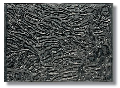
This is one of the woodblocks of the Daedongnyeojido, which was carved by the Joseon-era cartographer Kim Jeong-ho. The woodblock was produced in 1861 and then retouched several times afterwards.
The Daedongnyeojido (Territorial Map of the Great East) is one of the best maps produced during the Joseon Dynasty and was created to disseminate geographic knowledge. On the map, the nation is divided into 22 sections. Each section is designed to form a single volume when folded, making it portable. Taken together, the entire map is 3.8 meters wide and 6.7 meters long.
The woodblock is rich in geographical detail and was not only praised as a functional tool but also as a work of art.
*The photos and text for Treasure Trove are provided by the National Museum of Korea. For more information, call (02) 2077-9000 or visit www.museum.go.kr.


with the Korea JoongAng Daily
To write comments, please log in to one of the accounts.
Standards Board Policy (0/250자)