

49 old East Sea maps to be put on display
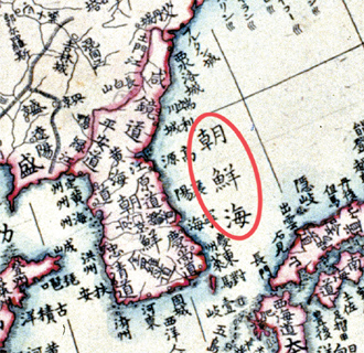
A Japanese world map from 1810 on display at the National Map Museum of the National Geographic Information Institute in Suwon, Gyeonggi, labels the body of water east of the Korean peninsula as the Joseon Sea, or the Korean Sea, in Chinese characters. Korea and Japan have long contested the official appellation of the sea. Korea claims it should be called the East Sea while Japan maintains it is the Sea of Japan. Provided by the National Geographic Information Institute
The Ministry of Land, Transportation and Maritime Affairs said that the exhibition at the National Map Museum of the National Geographic Information Institute in Suwon, Gyeonggi, would display 14 original maps from Japan and 35 from Europe.
Of the 49 centuries-old maps, 34 refer to the waters as the Sea of Joseon or Korean Sea, while five refer to it as both the Korean Sea and the Sea of Japan. The other 15 don’t label the sea.
Ten maps call the islets, claimed by both Korea and Japan, the Dokdo islets. The remaining maps don’t show the islets.
While duplicates of maps with the Dokdo labeling have been shown in Korea before, this is first time the originals can be seen in Korea.
Korea and Japan have long contested the official appellation of the body of water east of Korea separating it from Japan. Korea claims it should be called the “East Sea” while Japan maintains it is the Sea of Japan.
Both countries claim the Dokdo islets, which the Japanese call Takeshima.
Several 19th century Edo era Japanese maps on display mark the disputed waters as the Sea of Joseon, including ones from 1810 and 1850, while an 1863 map shows the Dokdo islets and Ulleung Island as Korean territories.
Likewise, a 1794 British map of “the Empire of Japan” also refers to the waters as the “Corean Sea” and includes the Dokdo islets and Ulleung Island in Korean territory.
Another 18th century French map of “L’Asie,” or Asia, marks the waters between Japan and Korea as “Mer de Coree.”
The first known map of Korea drawn by a Westerner, by French cartographer Jean Baptiste Bourguignon d’Anville in 1735, also likewise classifies the Dokdo islets and Ulleung Island as Korean territory.
“This exhibition is held to convey that Korea’s request to the International Hydrographic Organization for the joint use of the appellations East Sea and Sea of Japan is a valid claim,” said Han Sang-ho, a researcher at the National Geographic Information Institute.
Seoul wants the world to use both names - East Sea and Sea of Japan - while Tokyo wants only the use of the Sea of Japan.
Japan registered that as the official name with the IHO in the early 1920s, when Korea was under Japanese colonial rule.
The IHO deferred making a decision on the appellation of the sea for another five years in April.
By Choi Sun-uk [sarahkim@joongang.co.kr]


with the Korea JoongAng Daily
To write comments, please log in to one of the accounts.
Standards Board Policy (0/250자)