

Typhoon Soulik could batter Seoul overnight
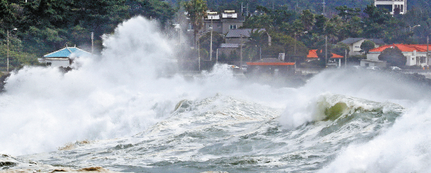
Waves are high in the sea near Seogwipo, Jeju Island, as Typhoon Soulik passes by the island Wednesday, It is predicted to make landfall on the peninsula today. [NEWS1]
“The typhoon is expected to get stronger after it passes the sea near Jeju Island,” said Yoo Hee-dong, director of the forecast division of the Korea Meteorological Administration (KMA). “Its impact on the country is expected to be larger than that of Typhoon Kompasu because it is expected to have an influence for a longer period of time on the peninsula.”
Typhoon Kompasu made landfall here in 2010, causing 18 casualties and temporarily displacing some 1,300 people. Damages at the time mounted to 167 billion won ($149 million).
The medium-sized typhoon of 43 meters per second (96 miles per hour) maximum winds approached Jeju Island Wednesday and was forecast to make landfall today.
This will be the first time in six years that a typhoon will hit Korea. The last typhoon to make landfall was Typhoon Sanba in September 2012.
“The whole of the Korean Peninsula will be under the influence of the typhoon, which is expected to move at a very slow pace,” Kim Seung-bae, a director of the Korea Meteorological Industry Association, said in a CBS radio show Wednesday. “That just means more destruction while it passes.”
The eye of the typhoon is expected to be closest to Seoul overnight from today to tomorrow, the KMA said. The Seoul city government sent out a warning via phone Wednesday evening to “be wary of the typhoon and strong winds in the city from the afternoon of Aug. 23.”
“Watch out for accidents outdoors as attachments to buildings may fall, glass windows may be shattered and trees on the streets may be uprooted,” a KMA official said.
Rainfall ranging from 50 to 100 millimeters (two to four inches) is expected in Seoul, Gyeonggi, Gangwon, South Chungcheong and North Jeolla from today to tomorrow, with some areas experiencing more than 150 millimeters of rainfall, the KMA said.
Maximum rainfall of 400 millimeters was forecast for Jeju Island and southern coastal areas Wednesday.
The KMA issued a typhoon warning in Jeju Island and South Jeolla on Wednesday. A typhoon warning is issued when strong winds are expected over the land or sea, the total rainfall is expected to be more than 200 millimeters or when “warning levels” of flooding is expected.
Some 40 flights in and out of Jeju Island were canceled Wednesday afternoon. The KMA also issued on Wednesday a strong wind advisory in South Gyeongsang and South Jeolla. A strong wind advisory is issued when wind speeds exceeding 14 meters per second are expected on land.
No vessels should venture out to sea until tomorrow, the administration warned.
“Waves will be some five to eight meters [16 to 26 feet] high in the sea all around the country, from Wednesday to Friday,” a KMA official said.
The administration projected the typhoon’s maximum wind speed to drop to 37 meters per second this morning and to 32 meters per second by this evening. The typhoon was forecast to move northeast toward Sokcho, Gangwon, by tomorrow morning and pass into the sea that night.
BY ESTHER CHUNG, CHEON GWON-PIL [chung.juhee@joongang.co.kr]


with the Korea JoongAng Daily
To write comments, please log in to one of the accounts.
Standards Board Policy (0/250자)