

Typhoon Haishen expected to near Busan Monday
![Fierce waves batter the coast of Seogwipo, Jeju, on Sunday as Typhoon Haishen makes its way northwards into the East Sea. [YONHAP]](https://koreajoongangdaily.joins.com/data/photo/2020/09/06/415026ee-1e19-4ee1-805f-0bbe2dcf9d5c.jpg)
Fierce waves batter the coast of Seogwipo, Jeju, on Sunday as Typhoon Haishen makes its way northwards into the East Sea. [YONHAP]
Fearing a recurrence of the damage wrought by Typhoon Maysak, Busan and South Gyeongsang remained on edge over the weekend as Typhoon Haishen was projected to skirt along the country's east coast after crossing the East Sea Monday.
According to the Korea Meteorological Administration (KMA), Haishen was moving northwards in the Pacific Ocean, around 290 kilometers (180 miles) off the coast of Okinawa, Japan, at a speed of 22 kilometers per hour, as of Sunday morning.
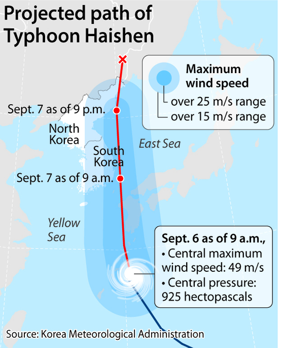
While at first projected to make landfall in South Korea, the predicted course for the storm was adjusted Saturday. Haishen was expected to come within about 60 kilometers of its eastern coast near Pohang, North Gyeongsang, on Monday afternoon.
Cold and dry air prevailing northwest of the peninsula were likely to push the storm to the east as it nears Korea, the KMA said, following its northward course across the west coast of the Japanese island of Kyushu on Monday morning.
After passing through the East Sea between the Korean mainland and Ulleung Island and the Dokdo islets, Haishen was projected to make landfall in North Korea’s North Hamgyong Province on Wednesday afternoon, with its intensity substantially reduced at that point.
The storm was nonetheless projected to lash Korea’s eastern coast with heavy rains and fierce winds, with areas adjacent to its path receiving up to 400 millimeters (15.7 inches) of precipitation throughout Monday.
The storm's classification was downgraded Sunday from “super strong” to “very strong” after the sustained wind speed at its center dropped from 56 meters per second to 49 meters per second.
The typhoon — the 10th to form this year — had a pressure of around 925 hectopascals at its center.
North and South Gyeongsang were due to receive around 100 to 300 millimeters of rain, North and South Jeolla between 100 to 200 millimeters and the rest of the country somewhere between 50 and 100 millimeters.
Winds were projected to reach speeds of up to 40 meters per second (89 miles per hour) in southeastern Korea and the eastern part of Gangwon, strong enough to knock an adult off his or her feet.
![Hundreds of fishing vessels are docked in Seogwipo harbor in Jeju on Sunday due to the approach of Typhoon Haishen. [YONHAP]](https://koreajoongangdaily.joins.com/data/photo/2020/09/06/25f1d3a0-f1d4-4894-acf6-8d746a6ad1bb.jpg)
Hundreds of fishing vessels are docked in Seogwipo harbor in Jeju on Sunday due to the approach of Typhoon Haishen. [YONHAP]
Coastal areas along the East Sea and the Korea Strait were also at risk of flooding from the storm surge, as the typhoon's arrival near Korea was due to coincide with the high tide, the KMA warned. This, combined with the low atmospheric pressure, could cause sea levels to rise a meter above average, said an agency spokesperson.
Recovery efforts in the aftermath of Typhoon Maysak had barely begun in Busan when the city was again plunged into high alert this weekend due to concerns over Haishen.
Officials were dispatched to inspect the city’s 59 drain pumping areas, as well as areas vulnerable to flooding. Objects like outdoor signs, trees, traffic lights and street lamps that could be knocked over with strong winds were also subject to inspection.
The KMA’s Busan branch said Haishen was projected to come nearest to the city at around 9 a.m. on Monday, with its center hovering over waters some 80 kilometers southeast of Busan.
Maysak, which tore through southeastern Korea last week, indirectly killed two people and left a host of damage in its wake. Around 75,000 households experienced varying degrees of blackouts, while evacuations forced around 2,800 people from their homes.
The storm ultimately left 58 people homeless after their residences were destroyed by the storm.
With Haishen holding the potential to wreak even further damage to devastated areas, the Korean government’s Central Disaster Management Headquarters on Sunday raised the country’s typhoon alert to its second highest level.
The KMA also warned that the storm’s projected course could again change as it moved north through the coast of Japan on Sunday evening.
BY SHIM KYU-SEOK [shim.kyuseok@joongang.co.kr]


with the Korea JoongAng Daily
To write comments, please log in to one of the accounts.
Standards Board Policy (0/250자)